Augmented Reality has been finding its place in the world more and more over the last year. One company has found a way to couple the AR platform with a new geographic information system (GIS) visualisation platform, dubbed vGIS. This could benefit not only the utility industry but us as consumers, too.
What is GIS/vGIS?
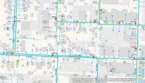
Example GIS System for water board companies, Software Advice
GIS is a Geographic Information System that allows the user to produce a map of a certain area, using specific details to that location. As an example, relevant to this article, utility companies currently use this technology so they can keep track of every detail necessary within their workspace. An electrical company would represent each wire and transformer, their exact location, and possibly other surrounding architecture for future planning. This gives an up to date and accurate platform to help with maintenance and the speed and efficiency in which it can be completed.
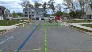
Example vGIS system showing underground infrastructure, vGIS
vGIS is a virtual Geographic Information System that is viewed through the medium of virtual reality, augmented reality and mixed reality. It takes the GIS technology and overlays it on a headset that workers can use to “see through” the ground at the infrastructure below. Rather than using a tablet, finding their exact location and then rotating the map depending on where they’re looking, the headset allows real-time updates on all of this information.
How can it benefit the utility industry?
Pipes burst, fibre cables require periodic maintenance, electrical cables get damaged in storms – it’s a part of life. Companies need to have the ability to react fast to these situations before they escalate. The Wall Street Journal published an article in 2016* that stated quality checks carried out by utility companies were up 20% by using vGIS. Production was up 25% too. This allows necessary works to be carried out with:
- Less disruption to us, the public
- Less time spent on the job, meaning less cost to the business
- More accurate details, minimising the frequency of future issues occurring
The innovation of vGIS has also led to utility companies coming together to further increase efficiency. Rather than 4 or 5 companies turning up to the scene of the problem with their separate GIS systems, leaving the opportunity open for miscommunication, a shared platform can be used. This results in everyone being on the same page; communication is always an important note in any area.
Where is it being used?
A company by the name of Toms River Municipal Utilities Authority piloted the technology. It uses the Microsoft HoloLens, with an application on tablets and mobile devices also, and is currently mainly being used in New Jersey, USA. However, there are many locations being served by the GIS and AR combination. California seems to be using the technology too, however not on quite such a large scale.
These vGIS programs combine geological data, custom maps, 3D building models, various scans, and a whole lot more. By having this data in the cloud, it can be uploaded, converted and delivered to the device platform in real-time.
What does it require?
[clickToTweet tweet=”If you’re thinking of using #AugmentedReality in your company, there are a few things to think about before you get started. #AR #VR #MR” quote=”If you’re thinking of using augmented reality in your company, there are a few things to think about before you get started.”]
If you’re thinking of using augmented reality in your company, there are a few things to think about before you get started.
- Why do you want to implement AR? What processes will it improve? What challenge will it resolve? It’s important not to jump on the bandwagon because it’s the latest “buzzword”. Always ask “why am I doing this?”
- Once step 1 has been fulfilled you will need to go out and map your assets and locations. This could be your underground infrastructure, your warehouses, etc. Accuracy is key as it will shape how effective the experience is.
- Configure your geographic information system database to include any and all attributes important to the operation. This could be material and installation date, for utility companies, or stock expiration, material, etc. for warehousing. Like all records, they should be accurate and complete.
- The last step might go against the grain of standard business practice, but partnering with other organisation to share data is quite critical. This will help develop the AR world and allow technology to progress faster. This benefits other companies but also yours! Progression means cheaper future processes thus increasing overall revenue.
The effect augmented reality is having on businesses
vGIS has the ability to provide a new level of operational intelligence, inspiring new services, improving current safety protocols and drives efficiency. Currently, around 400,000 US workers are using smart glasses and Forrester Research predicts that in 2025, that number will be closer to 14.5 million. In the same period, company spending on the technology is expected to increase from $6 million to $3.6 billion.
Businesses aside, it could benefit us in our daily lives too. When planting those summer flowers, I can’t be the only one to accidentally dig through an important pipe in the garden. Or when putting up a shelf and there’s that moment of “Am I about to put a nail straight through a power line”.
Next in the series, Wednesday 25th April 2018…
Tech of the week #7: From Supersonic to Hypersonic – a hybrid of space and flight
Concorde still remains a pinnacle of technological success thanks to its faster-than-sound flight speeds. The last flight of this wonder was just under 15 years ago, and since then there hasn’t been another aeroplane to come close to Concorde’s speeds. This could soon change thanks to a super-fast jet engine that doubles up a space-bound rocket…
If you want to talk tech, in this reality or another, get in touch via Twitter @JoshuaOsborn16.
*Wall Street Journal article here
Cover image from vgis.io
I work for Compare the Cloud as programme manager. I enjoy cybersecurity, fintech and, on the less boring side of things, photography, trains (I said less boring, right?) and, like everyone else, music.


