A city digital twin could become as basic to urban planning as a map
A city digital twin could become routine planning infrastructure. Japan's approach shows why British buyers should start with reusable data, clear ownership and a decision worth improving.


A shared city digital twin should become routine planning infrastructure for British councils and businesses, provided it earns its maintenance budget through better decisions. Japan’s smart-city architecture offers a useful direction through reusable geographical data and connected services. The British opportunity is to make developments, transport and infrastructure intelligible together, with clear ownership of the information and explicit limits on what the model can tell us.
Key pointers
- Start with a planning decision that needs information from different asset owners.
- Require suppliers to demonstrate data exchange using your records before committing to a platform.
- Give every shared dataset an owner, an update schedule and a stated accuracy.
- Separate the cost of building a model from the cost of maintaining it.
- Keep an existing mapping system when it can answer the question adequately.
- Make data export and supplier handover part of the acceptance test.
Japan is making shared urban information a policy choice
Japan provides a concrete starting point for this forecast. Its Cabinet Office describes a City OS as the data-linking foundation beneath smart-city services, supported by management, local strategy and physical assets. The reference architecture is intended to help services connect within and between cities and make successful approaches easier to reuse. These are stated design objectives, rather than proof that every participating city has achieved them.
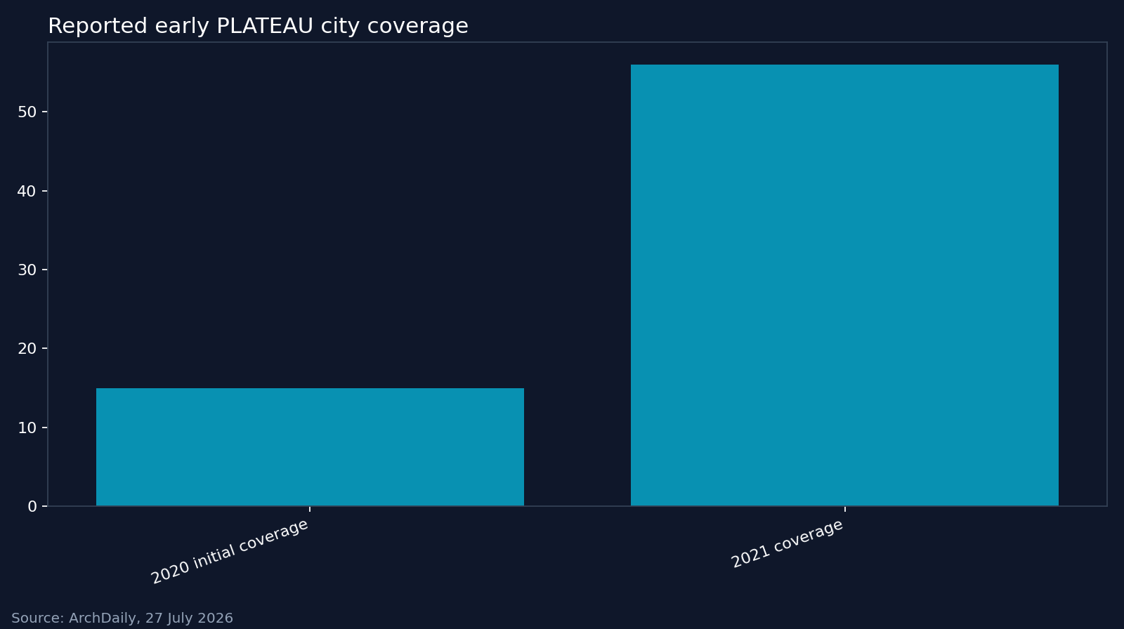
There is also a growing stock of digital urban models. ArchDaily’s July 2026 account of Project PLATEAU reports an initial 15 cities in 2020, expanding to 56 by 2021, with models of more than 250 cities available by the time of publication. It reports a target of 500 cities by 2027. Those figures describe model coverage, with the last figure a target, rather than a count of cities operating continuously updated twins.
The distinction matters. A model’s availability says little about whether somebody updates its building records, validates its predictions or uses it to approve a development.
The more consequential policy choice sits underneath the visualisation. Japan’s 2025 geospatial supplement describes a common mapping environment that integrates public, private, academic and citizen data. It specifies separate responsibilities for supplying data, converting and distributing it, and developing applications.
British buyers should take that separation seriously. A council should be able to improve its planning application without commissioning another copy of the underlying city.
What British companies should prepare for
For this argument, a city digital twin means a representation connected to evidence about the place it describes and used to inform decisions. That follows the connection to physical reality in the Gemini definition. It does not establish a universal requirement for every input to refresh every second.
Consider a hypothetical British regeneration scheme beside a river. The developer supplies proposed buildings and access routes. A transport operator supplies service information. The relevant infrastructure owners provide agreed records of their assets, while the planning team brings the geographical information needed for the assessment.
A shared view could help those organisations examine how a proposed road closure interacts with access to the development. A validated flood model could add a different question about the same location. Neither capability should be assumed merely because the buildings appear on screen.
For property groups, the preparation should begin with usable asset records and the rights to share them. For infrastructure suppliers, it should begin with documented interfaces and an agreed way of identifying locations. For a small British software business, the opportunity could be a focused application that uses this information, such as a maintenance planner, without owning the entire city platform.
My forecast is that compatibility with shared urban data will become a more important procurement question. The evidence supports preparing for that possibility, not announcing an inevitable market or a deadline for adoption.
The architecture needs named owners
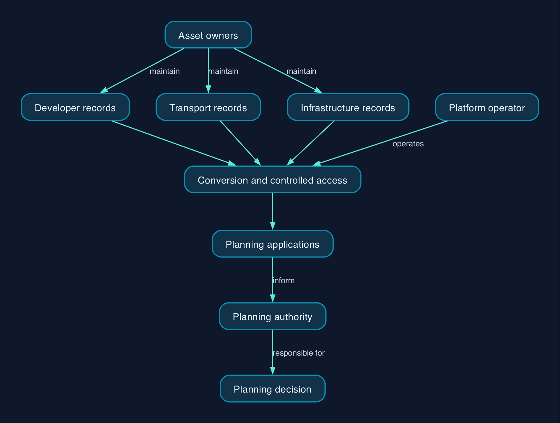
Japan’s geospatial supplement provides a practical mechanism. Original records sit in a data layer. A linkage layer collects them, converts them into agreed formats and distributes them. Applications then use those outputs.
Applied to the hypothetical regeneration scheme, that suggests the following allocation of responsibility.
The asset owners maintain their source records. A platform operator manages conversion, access and distribution. Application suppliers build the planning tools. The planning authority retains responsibility for the decision and for deciding whether the evidence is adequate.
The update path deserves as much scrutiny as the first import. A supplier demonstration should show what happens when a source changes, a feed stops or two organisations disagree about the same asset. The interface should expose uncertainty and missing information where they affect the decision.
Access should follow the use case. A public consultation map and an operational infrastructure model need not expose the same records. The Gemini Principles summary explicitly envisages selective connections between twins and sharing only where it delivers value and is appropriate and safe.
Budget for the information after the launch
A British buyer should request a whole-life quotation covering the model, its connections and the people responsible for keeping it useful. The following are proposed quotation requirements, not published market prices.
| Cost component | What the quotation should establish |
| --- | --- |
| Data preparation | Which records need cleaning, permission checks, conversion or new collection |
| Platform operation | Hosting, access management, monitoring, maintenance and support responsibilities |
| Model assurance | How assumptions, accuracy and suitability for each decision will be checked |
| Staff and adoption | Training, time to maintain records and ownership when a supplier escalates a problem |
| Exit and replacement | Export formats, documentation, transfer assistance and the cost of replacing components |
A limited pilot should compare the proposed workflow with the existing one. Measure something the buyer can observe, such as the time needed to assemble an agreed evidence set or resolve conflicting asset records. Continue only if the improvement justifies the recurring work.
That approach is consistent with the UK programme’s emphasis on incremental delivery and measurable benefits. It also gives a smaller supplier a bounded problem to solve.
Compare components before buying a city platform
The available architectural evidence supports comparing implementation roles more confidently than ranking commercial suppliers. Japan’s geospatial supplement identifies several named options, each doing a different job.
| Option | Role described in the supplement | Question for a British buyer |
| --- | --- | --- |
| CKAN | A possible catalogue in the original data layer | Who maintains the catalogue and checks its records? |
| MapLibre GL JS | An open-source library for displaying vector map tiles | Who builds and supports the application around it? |
| deck.gl | An open-source library for visualising data in three dimensions | Does this view improve the decision enough to justify maintaining it? |
| FIWARE | An open-source platform for managing changing context information, including sensor data | Which changing inputs are necessary, and who handles failed feeds? |
These are complementary components, not interchangeable city-twin products. Their appearance in a reference architecture is not evidence of a particular supplier’s delivery quality or a complete support service.
Procurement should leave room for an existing geographical information system, a modular implementation or a managed service. Require each proposed delivery approach to demonstrate the same data exchange, maintenance and exit conditions. A managed-service bidder should identify its retained customer responsibilities; a modular bid should name whoever will resolve faults spanning several components.
The strongest objection is that a good map may be enough
The strongest counterargument is economic. If an existing geographical information system already answers the planning question, a city twin could add integration work and maintenance obligations without improving the decision.
That objection should defeat a weak proposal.
The Gemini Principles summary makes accuracy dependent on purpose and explicitly rejects the need to connect every twin to every other twin. It offers a sound basis for resisting unnecessary scope.
For a consultation on proposed building heights, a maintained model and clear drawings may suffice. For a decision involving changing conditions across several operators, connected information may earn its keep. The buyer should make that distinction before choosing the technology.
There is also a political limit. A shared model can expose assumptions about development, access and infrastructure, but it cannot decide whose priorities should prevail. My recommendation is to preserve the assumptions, alternatives and named decision-maker alongside the output, so a persuasive visualisation remains open to challenge.
Editorial analysis
British councils and businesses should prepare for shared digital twins by making their information reusable now. Agreed asset identifiers, documented formats and explicit maintenance responsibilities are sensible requirements even if the first project remains an ordinary map.
Japan’s contribution to this debate is a worked architectural direction. Britain already has its own principles for purposeful, trustworthy digital twins. The next useful step for a buyer is to select a decision that crosses organisational boundaries and prove that sharing information improves it.
A city twin could become as basic to planning as a map when maintaining it becomes an accepted operational responsibility. Until a proposal names who corrects the records and pays for the next update, its business case is unfinished.
FAQ
Does a city digital twin need live sensor data everywhere?
No. The Gemini Principles summary allows different temporal scales and static or dynamic representations. Set the update frequency according to the decision, and show users when important information was last refreshed.
Should a British council commission a complete model of its city?
Only if the scope has a defensible purpose and maintenance budget. The UK programme principles favour incremental delivery with measurable benefits. A bounded project can test whether connecting information improves an existing planning process.
Can smaller British suppliers participate?
Buyers should make participation possible through documented interfaces and manageable delivery scopes. Japan’s geospatial architecture separates applications from the preparation and distribution of underlying data. That provides a design route for a specialist application supplier, although actual access depends on the project’s contracts and implementation.
Does shared data mean every record becomes public?
No. The Gemini Principles summary distinguishes potentially shareable information from information that is actually shared. Buyers should specify permitted users and purposes for each dataset before connecting it.
Sources
- Cabinet Office, Japan — Smart Cities, including the reference architecture edition dated 11 March 2026.
- Cabinet Office, Japan — Society 5.0.
- Cabinet Office, Japan — Geospatial Data Interoperability Platform, second edition, dated 23 May 2025.
- ArchDaily — From Data to Digital Twins, Japan’s PLATEAU Project Offers Open-Access Models of More Than 250 Cities, published 27 July 2026.
- Centre for Digital Built Britain — Gemini Principles, describing the principles published in December 2018.
- Centre for Digital Built Britain — The Gemini Principles summary.
- GOV.UK — National Digital Twin Programme principles, updated 12 January 2024.